Navigation sensors

DIGINEXT is a provider of military navigation systems for both surface and submarine vessels, new programs and ships upgrade, from small vessels up to aircrafts carriers.
DIGINEXT is the long-term and preferred partner of the French Navy and its Prime Contractor DCNS for high-profile platform development programs (e.g.: European Multi-Mission Frigate FREMM, Nuclear-Powered Attack Submarine BARRACUDA, French SSBN and Charles de Gaulle Aircraft Carrier) and other international projects (e.g.: Conventionally-Powered Attack Submarine SCORPENE).
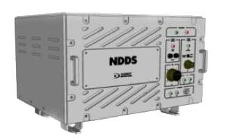
- Architect of navigation systems through studies, development and through-life support of Navigation Data Distribution Systems. NDDS elaborates, from data collected by sensors, the reference navigation information to be distributed to the on-board systems (e.g.: CMS, SMS ...).
- Designer of radio-navigation sensors through the development of the new generation of SAASM-based military GPS receiver and LORAN-C receiver with extended coverage.
- Producer of large series on-board and real-time systems (HW/SW) that are ruggedized for the most severe environments.
DIGINEXT is able to provide complete on-board navigation systems for naval forces with products ranging from navigation sensors (Military GPS Receiver and LORAN C) to navigation data processing, distribution and display (NDDS, CCU and NAV Repeater.)
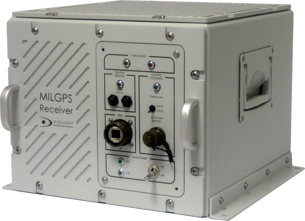
MILGPS
Its ongoing development process enables STARLINX, through his full standard implementation, to be involved in all kind of operation from Air to Air campaign, Ground Based Air Defense operations (GBAD), Air Surface Integration (ASI-ALI), Anti-submarine (ASW) and Surface (ASuW) even in Ballistic Missile Defence (BMD)
Applications
- Continuous high performance navigation on surface vessels
- High protection against jamming
- Optimized for military submarine navigation
- Quick alignment of GPS guided missiles
Key advantages
MILGPS is a Military GPS P(Y)-capable Receiver System for ship applications providing high-performance positioning with latest SAASM technology (using Thales GNSS 1000S board).
It is one of the the sole non-US receiver certified as following CZU-00-002 US DoD guideline, mandatory for SAASM based military GPS applications.
MILGPS has been selected by several European Navy organizations (France, Netherlands, Belgium, Portugal) to equip different types of vessels. It can be produced over large series to meet the need for legacy radio-navigation equipment retrofit programs.
This product allows Navy users to dispose of a P(Y) GPS solution that integrates the specific requirements and constraints of the Navy based navigation. Such as:
- Enhanced GPS capability, beyond traditional performances, such as Direct P(Y) acquisition and Precise Time Service (PTS) function for extended standalone operation without any external aiding.
- Optimal jamming mitigation:
- High performance Thales GPS Module (1)
- Robust Direct P(Y) feature
- Fully CRPA capable
- Coupling with INS and other Navigation sensors
- Flexible interfacing & quick onboard installation on new platforms or retrofit programs
- Upgradable to next generation GNSS (e.g.: M Code, Galileo)
- Provides ruggedized Navigation console
- Architecture adapted for customization:
- Custom I/O
- Integration in customer’s designed enclosure
- Fully redundant configuration available
- Compliant with CRPA antenna
Navigation Data Distribution Systems (NDDS)
Applications
In this context, with our NDDS solutions:
- We provide Gateway-Oriented architecture: Fully customizable system for easy CMS/SMS integration,
- We are sensor provider independent: We can be interfaced with any type of sensors from most vendors, especially regarding INS,
- We currently have more than 100 vessels at sea or in production using our Navigation systems / Equipment: Using Diginext NDDS provides benefits to both shipbuilders and Navy operational users.
Key advantages
As shown below, the NDDS is the core of the navigation network acting as a central and smart gateway from heterogeneous sensors to different types of subscribers.
NDDS helps integration of heterogeneous navigation sensors with CMS & SMS (e.g.: flexible I/O configuration and programmable data distribution).
It provides tools for testing and validation of both sensors and subscribers (e.g.: full simulation functions, raw data recording & scenario playback).
As all I/O can be software controlled/updated it optimizes future ship upgrades & maintenance.
On another hand, End user operational benefits are related to following features:
- Supervision of the whole navigation system: sensors & links failure detection, data consistency and integrity check,
- Distribution of the best navigation information 24/7,
- Inertial sensors update.
Depending on your ship integration constraints:
- Different forms of factors are available,
- All I/O interfaces can be fully customized,
- Core system is designed to match tight performance constraints,
- Flexible architecture: stand alone or fully redounded, SAASM P(Y) GPS can be integrated
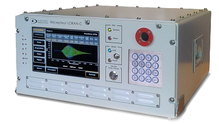
LORAN-C
Applications
- Highest protection against Jamming
- Sole radio navigation system independent from GPS
- Backup of conventional military GPS
- Submarine autonomous and discreet navigation via buoyant wire antenna
- Time & frequency synchronization
Key advantages
- Loran-C is a 2D positioning for Land & marine applications. It is based on ground beacons with high power broadcasting in LF band (100kHz).
- It is the sole radio navigation system independent from GNSS & foreign MoDs.
- It is barely impossible to jam Loran C signal: The involved range of emitted power naturally protects Loran C against jamming.
- It is an efficient, autonomous and discreet submarine navigation solution via buoyant wire antenna.
- Loran-C can be used as backup of conventional military GPS (Positioning & Timing).
- Extended navigation range (Circular mode),
- Enhanced positioning with INS aiding,
- ASF automatic correction, blink detection,
- Optional SAASM military GPS hybridization,
- eLoran ready.